 NEW BEDFORD, Mass./April 18, 2019 – Navionics, Inc., a Garmin® company, today announced that it has developed new SonarChart Shading for its exclusive Platinum+ and HotMaps Platinum cartography products for coastal and inland fishing and boating.
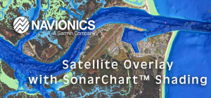
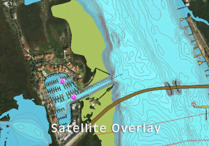
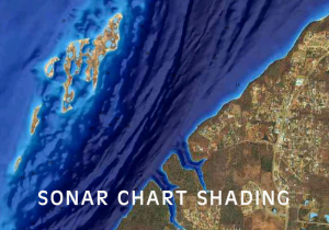
Embedded within the satellite overlay content layer, SonarChart Shading provides a detailed rendering of the seafloor and lake bottom to deliver a unique perspective of underwater topography at a glance. Created from the high-definition 1’ contour data within SonarChart, varying shades of blue reveal changes in depth, highlighting channels, drop-offs, and other features that help boaters quickly gain a better situational awareness and offers inland and coastal anglers clear, visual cues to identify fish-holding structure.

“SonarChart Shading is a natural progression of SonarChart,” said Marcello Albanese, Navionics director of sales and business development. “It puts to use the enormous amount of depth data we’ve amassed from proprietary surveys and crowd-sourced contributions in the form of a completely new visual display for our customers.”
SonarChart Shading can be viewed on the same GPS chartplotters that are compatible with HotMaps Platinum and Platinum+ satellite overlay and with the same options, including selectable overlay on land, land and shallows or full overlay. Adjustable transparency allows customers to view the new imagery blended with either the Son

arChart bathymetry map or the Nautical Chart.
At closer zoom levels, SonarChart Shading is replaced by the actual satellite imagery over water, allowing boaters to see a bird’s eye perspective of sandbars, marshes and backwater channels. In addition to SonarChart Shading, Platinum+ and more than 2,600 lakes HotMaps Platinum lakes will offer updated and optimized high-resolution satellite imagery. Some lakes may have partial coverage.
SonarChart Shading is expected to be available beginning in mid-spring with HotMaps Platinum for U.S. and Canada. Coastal coverage will follow with updated Platinum+ marine charts for U.S., Europe, Canada, and Central America, then South America and Australia by mid-summer 2019. Availability for other regions is expected by Q4 2019. To learn more, visit www.navionics.com.
Navionics products include a one-year subscription for daily updates to Nautical Chart, SonarChart and Community Edits as well as access to advanced features, such as SonarChart Live, Dock-to-dock Autorouting1, Advanced Map Options and Plotter Sync. As coverage areas are released, customers who own a Platinum+ or HotMaps Platinum chart with an active subscription will also be able to download or update the combined satellite overlay and SonarChart™ Shading layer for their region via the Chart Installer.
1Autorouting is for planning purposes only and does not replace safe navigation operations.
About Navionics Inc.
Navionics, a Garmin® company, develops and manufactures electronic navigation charts of marine areas, lakes, and rivers around the world for use in GPS chartplotters and mobile devices. Navionics, based in Viareggio, Italy, operates a US headquarters in New Bedford, MA, and worldwide offices in the UK, India and Australia.
About Garmin
Garmin is incorporated in Switzerland, and its principal subsidiaries are located in the United States, Taiwan and the United Kingdom. Garmin is a registered trademark of Garmin Ltd.
All other brands, product names, company names, trademarks and service marks are the properties of their respective owners. All rights reserved.
Notice on Forward-Looking Statements:
This release includes forward-looking statements regarding Garmin Ltd. and its business. Such statements are based on management’s current expectations. The forward-looking events and circumstances discussed in this release may not occur and actual results could differ materially as a result of known and unknown risk factors and uncertainties affecting Garmin, including, but not limited to, the risk factors listed in the Annual Report on Form 10-K for the year ended December 29, 2018, filed by Garmin with the Securities and Exchange Commission (Commission file number 0-31983).
A copy of such Form 10-K is available at http://www.garmin.com/aboutGarmin/invRelations/finReports.html. No forward-looking statement can be guaranteed. Forward-looking statements speak only as of the date on which they are made and Garmin undertakes no obligation to publicly update or revise any forward-looking statement, whether as a result of new information, future events, or otherwise.
See the latest in bass fishing here

